2-3 Mass Wasting
Figure 5.1.1 in the textbook is a technical way of showing what is obvious to almost anyone, and that is the steeper a slope, the more likely that some type of slope failure will occur. A less obvious part of that relationship is that the weaker the material on a slope (the length of the green arrows on 5.1.1.), the more likely that it will fail. The strength of material on a slope is partly determined by what it is made of, and as shown on Figure 5.1.2, planes of weakness have significant implications for the strength of any material on a slope. Planes of weakness will make any material weaker than it would be otherwise, but the closer that those planes of weakness are to being parallel to the slope the greater the likelihood of failure. Terminology is important in all aspects of knowledge, and there is a significant terminology point made at the start of section 5.1 about the word “landslide.” It is one of those words that is widely used by the press and public officials, but it suffers from ambiguity, and it should be avoided by students in this course. Either of the terms “mass wasting” or “slope failure” can be used (interchangeably) to describe what most people think of when they say “landslide,” but, when we know what actually happened, it’s much better if we can use more specific terms like “rockslide,” or “debris flow.”
Summarized on Figure 5.1.4, the presence of water within any material on a slope is also significant to the strength. A small amount of water can help to bind grains together, but too much water will push them apart, and weaken the material. This also applies to solid rock, where water along fractures and bedding planes can reduce overall strength. And, as discussed above, water is particularly significant if the material on a slope includes any clay minerals. As described in Box 2-1 below, clay minerals, especially swelling clays, lose strength when they are saturated with water.
Box 2-1 Slippery Clays
There is a lab activity in Assignment 2 (in the Assessments Overview tab in Moodle) in which you are asked to work with clay minerals to find out how much water they can absorb. One of the samples provided is a swelling clay. When you’ve done that activity, put some of the wet clay between your thumb and finger to feel how slippery and weak it is. That slipperiness is a result of the individual sheets of the clay mineral sliding past each other because they have been pushed so far apart by water molecules that they are only weakly held together (see Figure 2-2). If you haven’t yet worked on that lab, this might be a good time to do it.

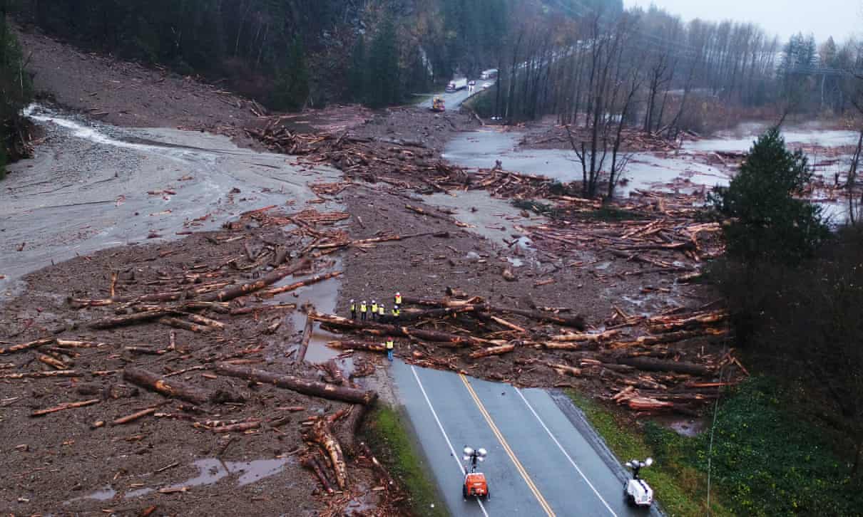
When a slope failure happens, the public, the press, geologists, and engineers typically ask questions like, “why did this happen now?”, or “what triggered this?”. In many cases the answer is obvious, or at least appears to be. A sudden torrential rainstorm, like the ones that hit British Columbia and Washington State in November 2021, can easily trigger slope failures (Figure 2-3 below), as can an earthquake (illustrated in Figure 5.1.7 in the textbook). Freezing and thawing events can also trigger failures, although in most cases those are relatively small rock falls. But in many cases, there is no obvious answer to the “why now?” question, and it may just be that steep slopes are continuously being weakened by weathering processes, and some fail when it is least expected. This may be particularly true in glaciated regions where steep-sided valleys that were once nearly filled with ice have little or no ice left, and the rock of the slopes has gradually expanded (because the pressure of the ice has been removed) and are becoming weaker as a result. This may be the explanation for the rockslide that triggered the Elliot Creek debris flow that is described in Box 5.1 in the textbook, and in Box 2-2 with the videos linked below.
Section 5.2 of the textbook provides an overview of the criteria for classifying slope failures. Classification is very important, because if we understand the nature of a failure, we have a better chance of understanding how to avoid danger to the public the next time one happens, and, in some cases we might even have a chance of predicting and/or delaying that occurrence. The key classification parameters are the type of material that failed—whether it was solid rock or unconsolidated sediments—and the manner in which it failed: flowing as a liquid or sliding as a single unit. The rate of motion is also important, although that can vary quite widely within a single classification.
There are several ways of monitoring a slope to determine the risk of a future failure, and some of these are discussed in the textbook. Another important aspect of assessing failure risk is to monitor weather conditions, and this is becoming increasingly significant with the more extreme weather patterns that are associated with climate change.
The steel-cable monitoring device shown on Figure 5.3.2 in the textbook has a thermometer attached to it. Why do you think it’s important to know the temperature at this location?
Predicting slope failures, and trying to warn of slope failures that are already happening, isn’t possible in most cases, but there are some ways to limit risks to people and infrastructure, as summarized in the last few paragraphs of section 5.3. The lahar detection system installed on the flanks of Mt. Rainier in Washington is not a slope failure prediction system, but a warning of a failure that is already underway. It is designed to give residents a chance to get to a safe location in the event that a debris flow is detected.
Box 2-2 The Elliot Creek Slope Failure
Box 5.1 in the textbook provides an overview of the events of the November 2020 mass wasting events at Elliot Creek and the Southgate River in the Bute Inlet area of British Columbia.
Those events are described in a different format in this two minute video (this video has no sound track):
You can also view the presentation as a pdf (some functionality may be lost): The November 28th 2020 Elliot Creek Debris Flow
The implications of the Elliot Creek slope failure for the Homalco First Nation are summarized in the video below, Understanding the Aftermath of the Bute Inlet Landslide, by Katrina Pyne, Grant Callegari, Kristina Blanchflower at the Hakai Institute.
